By Ryan Whisner
The Fort Atkinson City Council approved a preliminary certified survey map (CSM) and held a first reading for the rezoning of land for the planned development in the Banker Road area known as the Trillium Multifamily Neighborhood Development.
The Trillium Multifamily Neighborhood Development is the first part of implementing the neighborhood plan previously approved by both the Fort Atkinson Plan Commission and the city council.
Council members had few questions outside of inquiring if there had been any public input on the requests.
After unanimously approving the CSM, the council then advanced the rezoning of the property from SR-2 single-family residential to MRH-30 multifamily residential to its next reading at the council’s May 16 meeting.
The two actions related to the 74.12 acres along Banker Road acquired by the city in 2021. With Vandewalle and Associates developing a neighborhood master plan, the area was annexed into the city that year and is included in the new Tax Incremental Financing District No. 9.
In September 2022, the council chose the Hoffman Development Group LLC and CedarPrise LLC team as the master developer to develop the multifamily components of the neighborhood plan.
As recently presented to the Plan Commission, the preliminary plans are for three four-story buildings consisting of a total of 141 apartments in what has been designated as the Trillium Multifamily Neighborhood Development.
Fort Atkinson City Engineer Andy Selle noted that the CSM includes the dedication of new public right-of-way for an 80-foot road, to be named Trillium Drive, along the northern edge of the parcel, as well as right-of-way for a relocated Banker Road that is proposed in the development plan.
The Plan Commission held a public hearing at its meeting on April 25, at which time members of the public did not come forward.
Selle said the certified survey map was for the parcel that is being broken off the city’s 75 acres that will house the proposed development that required the rezoning.
“For now, we just simply need a box that we can apply the zoning to and that’s what this does,” he said, noting that the zoning map changes go through a clear set of criteria to be approved, all of which have been met.
“In this situation, the zoning that is being requested is multi-family residential or MRH 30,” he said. “That fits this development the best. If you recall, we also applied MRH 30 zoning to the privately owned parcel to the south that council looked at not too long ago with the new 36-unit building that was proposed near the high school driveway entrance.”
The council and Plan Commission had previously approved a zoning change at 1310-1320 Campus Drive, on land owned by Tip of The Spear LLC for two planned four-story, 36-unit apartment buildings.
Tip of the Spear anticipates construction will start this summer, with units within a first building made available to rent by May 2024.
Selle said one town resident did reach out, with whom he and City Manage Rebecca Houseman met.
“I would characterize their questions more as ‘what’s going on?’ and we kind of give them an update on the various developments out there,” Selle said. “That’s the only feedback I’ve received. I’m not aware of any other staff proceedings.”
Under the city’s zoning code, three buildings are not permitted on one parcel.
A separate action for a conditional use to allow the three buildings will come before the Plan Commission under a group development conditional-use review. That meeting will be in mid to late summer.
“This action is to accommodate the proposed project that includes three buildings. There will be another conditional use permit eventually that will go through this public process that will outline the exact locations of buildings, materials used for the buildings, and landscaping, more akin to the site plan review, so this is just the zoning portion for this project,” Houseman said.
An earlier story about the project, as discussed during a recent meeting of the city’s Plan Commission, is here: https://fortatkinsononline.com/trillium-development-moves-forward-in-fort/.
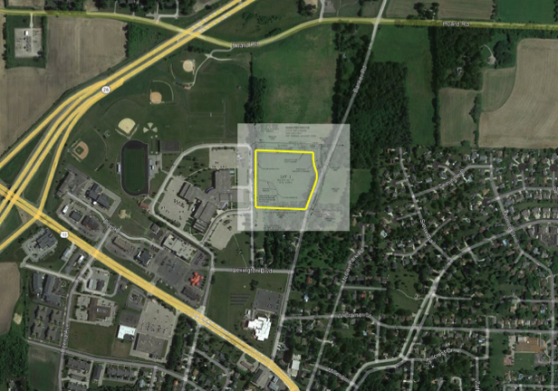
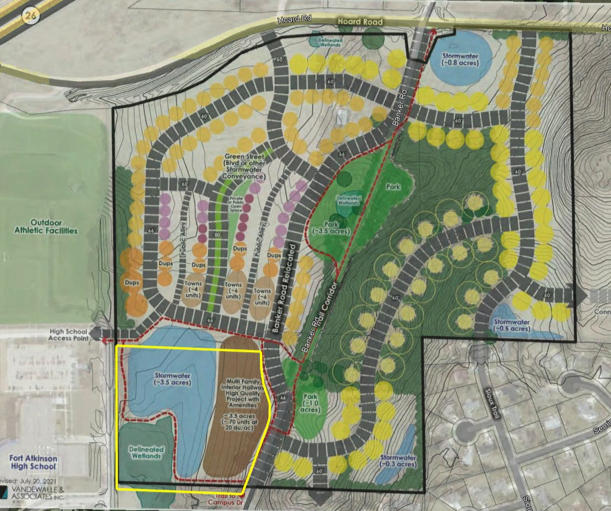
Two graphics above: Both maps show placement of elements within the project known as “Banker Road,” including a certified survey map which includes the approximately 8-acre Trillium Multifamily Neighborhood Development project. The certified survey map was approved Tuesday by the Fort Atkinson City Council, and a rezoning of land to accommodate the Trillium Multifamily Neighborhood Development received first-reading approval. Contributed graphics.
This post has already been read 1929 times!