
By Kim McDarison
Gov. Tony Evers this week signed into law a new set of Wisconsin legislative maps.
According to information released by the governor’s office on Monday, the enactment of the maps offered an opportunity for the governor to “keep a promise” he made to the residents of the state to “undo a decade of Wisconsinites living under among the most gerrymandered maps in the United States.”
The maps enacted Monday, the release stated, are legislative maps “as previously submitted to the Wisconsin Supreme Court and recently approved by the Republican-controlled Legislature with bipartisan support.”
The release further noted that the governor’s efforts “to secure fair legislative maps marks the first time in over fifty years that Wisconsin will have fair legislative maps enacted through the legislative process rather than through the courts.”
In the release, Evers said the enacting of the maps was not a victory for himself or any political party, but for the residents of the state, who, he said, have “spent a decade demanding more and demanding better of us elected officials.”
He continued: “I believe, as I’ve often said, that the people should get to choose their elected officials, not the other way around. And under the maps I’m signing … I am making good on that promise.”
The path to new maps
Maps signed into law by Evers this week were previously submitted by the governor to the Wisconsin Supreme Court for their consideration in redistricting litigation in “Clarke v. Wisconsin Elections Commission,” according to the release.
An earlier release noted that the maps, dubbed “Fair Maps,” were submitted to the state’s Supreme Court on Jan. 12.
The governor was quoted in the January release as saying: “Wisconsinites don’t want Republican or Democrat maps because Wisconsin isn’t a red or blue state — we’re a purple state, and our maps should reflect that basic fact.”
Last October, the governor, who was represented by Attorney General Josh Kaul, filed a motion to intervene in a lawsuit before the Wisconsin Supreme Court, challenging the state’s legislative maps.
Through the filing of that motion, the governor became a party in the legislative redistricting litigation then pending before the court.
In October, within a release, the governor said: “Wisconsin deserves fair maps — not the gerrymandered maps we have now that I already vetoed two years ago …”
Kaul, too, was quoted in the release, saying: “The extreme gerrymandering of our legislative maps has shifted power from where it ultimately belongs — with the voters — to the legislators who have drawn the maps.”
Also in October, Kaul filed a brief on the governor’s behalf, asking the Wisconsin Supreme Court to declare Wisconsin’s legislative maps unconstitutional and institute new maps that avoid partisan bias.
He said the partisan bias in the maps had “infected” the maps “to the detriment of Wisconsin’s democracy.”
The brief argued that the court should declare the maps unconstitutional for “violating the constitution’s separation of powers” by adopting the exact legislative maps vetoed by Evers.
“The Legislature’s proposed maps perpetuated and likely worsened the existing partisan bias; they were vetoed by the governor,” the brief argued.
The governor argued that the maps were “clearly designed to benefit one political party over another and would preserve undemocratic majorities.”
Last December, according to the Jan. 12 release, the state Supreme Court found that the state legislative maps were “unconstitutionally noncontiguous.”
The court offered a process through which the litigating parties could propose maps and indicated it would consider several criteria when reviewing and evaluating the submitted maps.
Criteria, as held out by the court, was as follows:
• Whether the maps comply with population equality requirements;
• Whether districts conform to Article IV of the Wisconsin Constitution, which requires districts to be compact and contiguous;
• Whether the maps comply with federal law;
• The degree of municipal splits and how maps preserve communities of interest, and
• Whether maps have a partisan bias so the court can avoid “selecting remedial maps designed to advantage one political party over another.”
The maps, as submitted to the court, were passed by the Wisconsin State Legislature, with bipartisan support, last week, according to Monday’s release.
The release described the maps as “responsive to the will of the people,” while designed to avoid partisan bias, and increased the number of competitive legislative seats.
Additionally, the Monday release noted, the court had previously ruled that the legislative maps were unconstitutional, “leaving no legislative maps in place for the 2024 election.”
Maps enacted on Monday, “will take effect immediately after publication and will be in place for the fall election,” the release stated.
Primary and general elections for Wisconsin Assembly and Senate seats will be held Aug. 13 and Nov. 5, respectively. A filing deadline for candidates is June 3. Assembly members serve two-year terms. State senators are elected to four-year terms.
An earlier redistricting
Prior to Monday’s enactment, Wisconsin was using legislative maps which were adopted in April, 2022, when the Wisconsin Supreme Court ruled that legislative maps drawn by the Republican-controlled Wisconsin State Legislature would be used to define the Assembly and State Senate districts for a 10-year period.
The April ruling reversed an earlier decision, which was made by the Wisconsin Supreme Court and published in February, adopting legislative maps as submitted by Evers.
The Supreme Court of the United States published its reversal of the Wisconsin Supreme Court’s February ruling in March, clearing the path for the adoption of maps drawn by the state Legislature on April 15, 2022.
What are the changes locally?
Changes brought about by redistricting in April, 2022, affected State Senate and Assembly districts including those then-encompassing the cities of Fort Atkinson and Whitewater, and the surrounding area. With new maps enacted Monday, voters will once again need to learn new boundaries before heading to the polls in August and November.
Changes within districts affecting communities within the WhitewaterWise and Fort Atkinson Online readership areas, follow.
Assembly District 33
In April of 2022, and prior to Monday’s ruling, Assembly District 33 included in part or full, the communities of Fort Atkinson, Jefferson, Milton, Helenville, Hebron, Sullivan, Oakland and Palmyra. A portion of the city of Whitewater, which resides in Jefferson County, also was included. The portion of Whitewater residing in Walworth County was included in Assembly District 31.
The district is represented by Scott Johnson, R-Jefferson. With new maps enacted Monday, Johnson no longer lives within the district. His term ends Jan. 6, 2025.
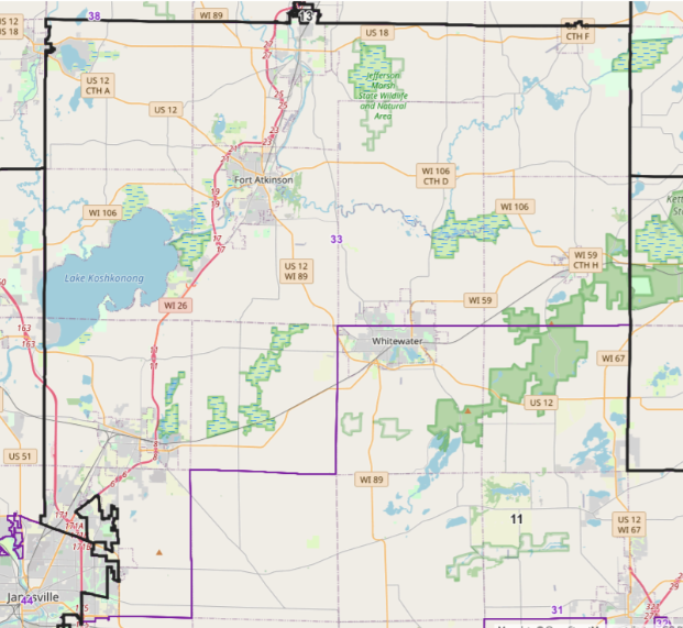
The image above shows Assembly District 33 after April 2022 and before Monday.
Maps enacted Monday, show the following communities within Assembly District 33: towns of Troy, East Troy, Spring Prairie, Rochester, Dover, Yorkville, Union Grove, and Lyons, and the cities of Lake Geneva and Burlington.

The image above shows Assembly District 33, depicted in green, following Monday’s enactment of new legislative maps.
Assembly District 38
In April of 2022, and prior to Monday’s ruling, Assembly District 38 included, in part or full, the communities of Marshall, Deerfield, Cambridge, Waterloo, Lake Mills, Aztalan, Johnson Creek, Farmington, and Rockdale.
The district is represented by Barbara Dittrich, R-Oconomowoc. With new maps enacted Monday, Dittrich no longer lives within the district. The representative assumed office in 2019, with her current term ending Jan. 6, 2025, according to Ballotpedia.org.
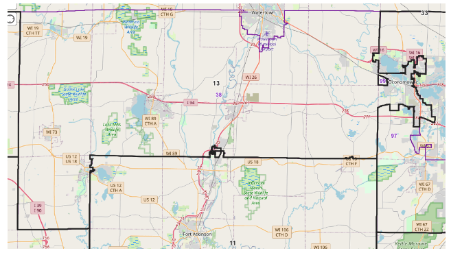
The image above shows Assembly District 38 after April 2022 and before Monday.
Maps enacted Monday show the following communities within the district: towns of Johnson Creek, Milford, Shields, Reeseville, Lowell, Clyman, Emmet, Oak Grove, Hubbard, Hustisford, Horicon, Iron Ridge, Farmington and Herman, along with the cities of Watertown and Jefferson, and the villages of Clyman and Hustisford.
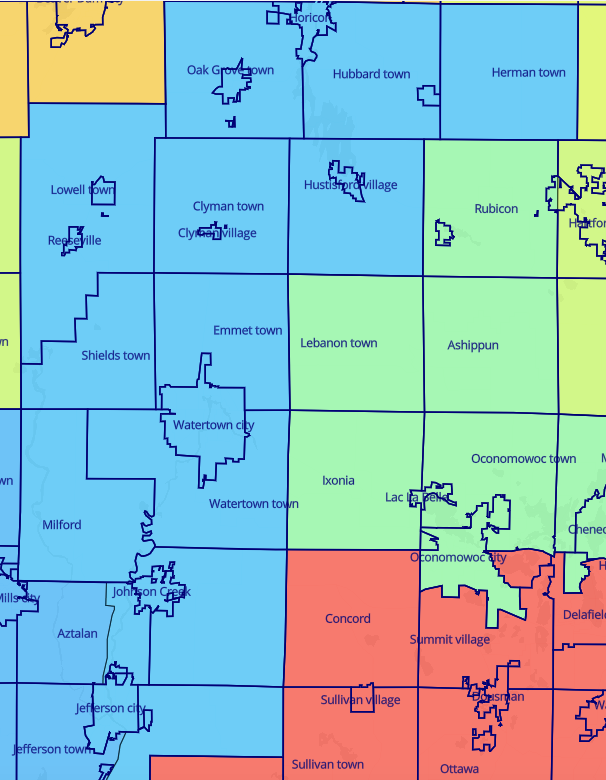
The image above shows Assembly District 38, depicted in a slightly lighter blue, following Monday’s enactment of new legislative maps.
Assembly District 31
In April of 2022, and prior to Monday’s ruling, Assembly District 31 included, in part or full, the communities of Whitewater, Elkhorn, Darien, Avalon, Richmond, Johnstown, La Grange, Sugar Creek, La Prairie, Bradford, Darien, Turtle and Clinton.
The district is represented by Ellen Schutt, R-Clinton. With new maps enacted Monday, Schutt remains in her district. According to Ballotpedia.org, Schutt assumed office in January of 2023, with her term ending in January of 2025.
The image above shows Assembly District 31 after April 2022 and before Monday.
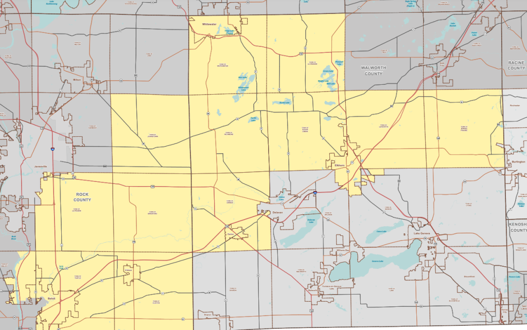
Maps enacted Monday show the following communities within the district: towns of La Grange, Sugar Creek, Lafayette, Bradford, Darien, Clinton, Sharon, Walworth, Delavan, Geneva, and Linn, and the cities of: Elkhorn and Delavan, along with the villages of Darien, Clinton, Sharon, Walworth, and Williams Bay.

The image above shows Assembly District 31, depicted in yellow, following Monday’s enactment of new legislative maps.
Assembly District 43
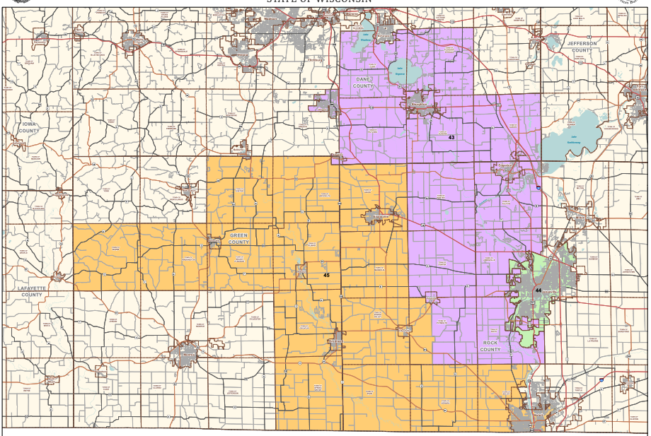
In April of 2022, and prior to Monday’s ruling, Assembly District 43 included, in part or full, the communities of Oregon, Dunn, Pleasant Springs, Stoughton, Rutland, Dunkirk, Albion, Edgerton, Porter, Fulton, Center, town of Janesville, Footville, Plymouth, and Rock.
The district is represented by Jenna Jacobson, D-Oregon. With new maps enacted Monday, Jacobson no longer lives within the district. Jacobson assumed office, according to Ballotpedia.org, on Jan. 3, 2023. Her term ends Jan. 6, 2025.
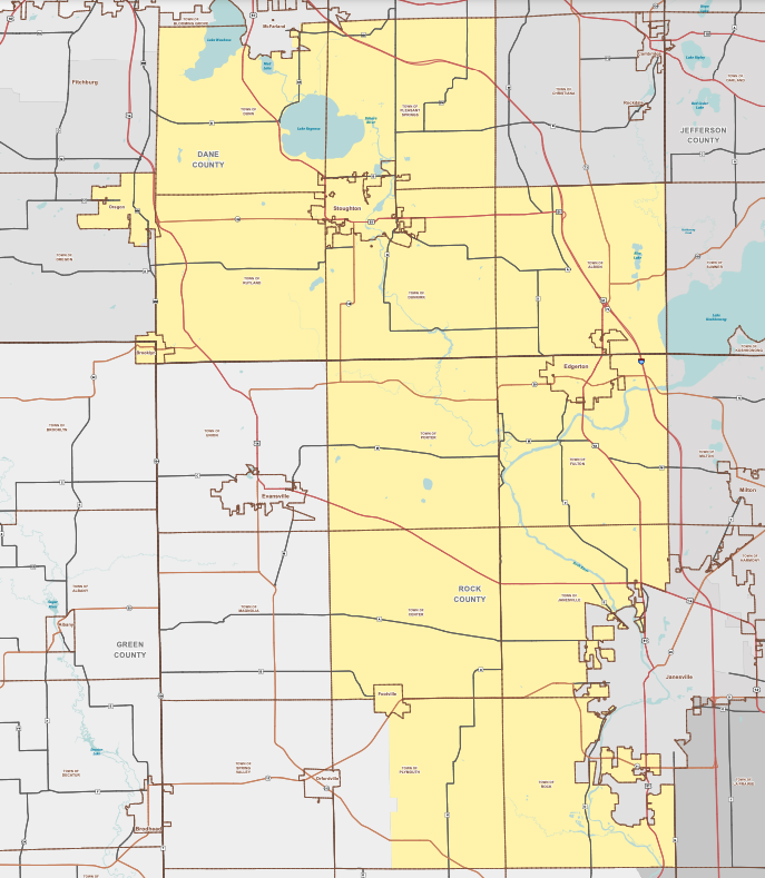
The image above shows Assembly District 43 after April 2022 and before Monday.
With the enactment of maps on Monday, the towns of Fulton, Milton, Lima, Whitewater, Johnstown, Cold Spring and Richmond, along with the cities of Whitewater, Milton, and a portion of Janesville are included in the district.

The image above shows Assembly District 43, depicted in orange, following Monday’s enactment of new legislative maps.
Assembly District 46
In April of 2022, and prior to Monday’s ruling, Assembly District 46 included, communities in Dane County, such as Sun Prairie and the town of Cottage Grove.
The district is represented by Melissa Ratcliff, D-Cottage Grove. With new maps enacted Monday, Ratcliff remains in her district. She assumed office in January of 2023, with her term ending Jan. 6, 2025. Ratcliff, who is looking to fill the Senate District 16 seat, is next scheduled to run in the Democratic primary on Aug. 13, according to Ballotpedia.org. Joan Fitzgerald, a Jefferson County Board Supervisor, recently announced her intentions to run for the Assembly District 46 seat.

The image above shows Assembly District 46 after April 2022 and before Monday.
With the enactment of maps on Monday, the towns of Medina, Waterloo, Cottage Grove, Deerfield, Aztalan, Rockdale, Oakland, Sumner, Koshkonong, and Jefferson, along with the cities of Waterloo, Lake Mills, and Fort Atkinson, and the villages of Cambridge and Cottage Grove are included in the district.
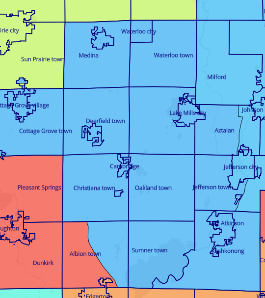
The image above shows Assembly District 46, depicted in a slightly darker blue, following Monday’s enactment of new legislative maps.
Senate District 11
In April of 2022, and prior to Monday’s ruling, Senate District 11 included, in part or full, the communities of Jefferson, Helenville, Sullivan, Fort Atkinson, Hebron, Palmyra, Whitewater, Milton, Avalon, Elkhorn, Delavan, Johnstown, Richmond, Darien, Clinton, Sharon, Williams Bay, Lake Geneva, Fontana, Walworth, Beloit and Genoa.
The district is represented by Steve Nass, R-Whitewater. According to Ballotpedia.org, his term ends Jan. 4, 2027. Nass served on the Wisconsin State Assembly, representing District 33, between 1990 and 2015. He has represented Senate District 11 since Jan. 5, 2015.

The image above shows Senate District 11 after April 2022 and before Monday.
With the enactment of maps on Monday, the towns of Troy, East Troy, Lafayette, Spring Prairie, Rochester, Dover, Yorkville, Union Grove, Paris, Brighton, Pleasant Prairie, Paddock Lake, Salem Lakes, Twin Lakes, Wheatland, Bloomfield, Linn, Lyons, Geneva, Walworth, Clinton, Bradford, and the cities of Lake Geneva, Elkhorn, Delavan, and Burlington, along with the villages of Sharon, Darien, and Boomfield, are included in the district.

The image above shows Senate District 11, depicted in red, following Monday’s enactment of new legislative maps.
Senate District 15
In April of 2022, and prior to Monday’s ruling, Senate District 15, in part or full, included the communities of Oregon, Stoughton, Brooklyn, Edgerton, Janesville, Footville, Orfordville, Brodhead, Albany, and Evansville.
The district is represented by Mark Spreitzer, D-Beloit. With new maps enacted Monday, Spreitzer remains within his district. Speitzer assumed office on Jan. 3, 2023. He will next run to retain his seat in November of 2026. His term ends in Jan. 4, 2027.
The image above shows Senate District 15 after April 2022 and before Monday.
With the enactment of maps on Monday, the towns of Union, Magnolia, Orfordville, Avon, Newark, Footville, Porter, Fulton, Janesville, Rock, Beloit, Turtle, La Prairie, Harmony, Milton, Lima, Johnstown, Whitewater, Cold Spring, and Richmond, and the cities of Evansville, Beloit, Janesville, Milton, and Whitewater are included in the district.
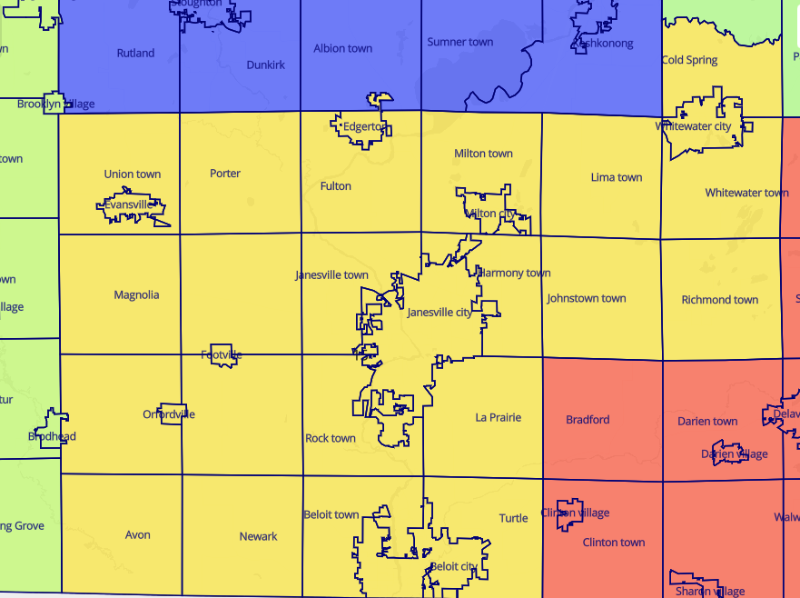
The image above shows Senate District 15, depicted in yellow, following Monday’s enactment of new legislative maps.
Senate District 16
In April of 2022, and prior to Monday’s ruling, Senate District 16, in part or full, included the communities Sun Prairie, Cottage Grove, Monona, McFarland, Blooming Grove, Fitchburg, town of Madison, and Maple Bluff.
The district is represented by Melissa Agard, D-Madison. With new maps enacted Monday, the city of Madison is not included in the district. Agard, according to Ballotpedia.org, assumed office on Jan. 4, 2021. Her term ends on Jan. 6, 2025. Melissa Ratcliff, D-Cottage Grove, and Jimmy Anderson, a Democrat who currently serves as the state representative in Assembly District 47, are looking to fill the Senate District 16 seat. The candidates will run in the Democratic primary on Aug. 13.

The image above shows Senate District 16 after April 2022 and before Monday.
With the enactment of maps on Monday, the towns of Elba, Bristol, York, Portland, Sun Prairie, Medina, Waterloo, Deerfield, Aztalan, Dunn, Christiana, Oakland, Jefferson, Rutland, Dunkirk, Albion, Sumner, and Koshkonong, and the cities of Fort Atkinson, Stoughton, Sun Prairie, Waterloo and Lake Mills, along with the villages of Cambridge and Cottage Grove, are included in the district.
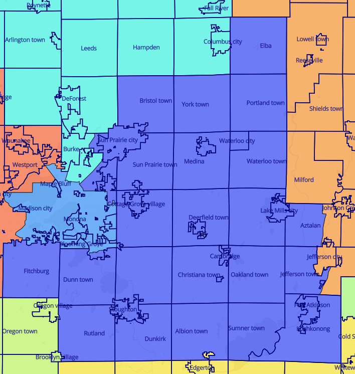
The image above shows Senate District 16, depicted in purple, following Monday’s enactment of new legislative maps.
An earlier story about legislative maps enacted in Wisconsin in April of 2022 is here: https://fortatkinsononline.com/musical-maps-assembly-and-state-senate-districts-drawn/.
This post has already been read 1451 times!