By Chris Spangler
The Fort Atkinson Plan Commission on Tuesday reviewed potential updates to the city’s official map and comprehensive plan.
City engineer and commission Secretary Andy Selle explained in a memo that the comprehensive plan sets the policy for the growth, development and preservation of the community, and the proposed amendments would affect its transportation and community facilities maps.
As outlined, the proposed amendments have:
• Re-evaluated and relocated proposed future off-street trails, on-street bicycle facilities, wells, parks and roads.
• Removed a few outdated elements regarding the future locations of a new hospital and the previously planned U.S. Highway 12 bypass.
• Added a new potential future airport expansion area and State Highway 26 overpass.
• Updated the City of Fort Atkinson municipal boundary to reflect the existing boundary.
Selle noted that the city revised its comprehensive plan in 2019 and zoning code in 2020, and is reviewing revisions to its Land Development and Division Code in 2022.
Only the comprehensive plan indicates planning beyond the city’s municipal boundary, citing a logical expectation for commercial, residential, park and reserved (wetlands, floodplains, etc.) lands within a reasonable distance of the boundary.
“Although these designations exist, the city has no real authority to influence development in these areas to ensure such logical future expansion is preserved,” Selle wrote in his memo. “This is intentional within the law to preserve private property rights and limit the reach of government.”
However, the law does recognize that planning ahead for the continuation of public right-of-way corridors and the public improvements (roads, sidewalks, water, sewer, cable, electric, etc.) beyond the borders of a city is in the best interest of all citizens, he explained.
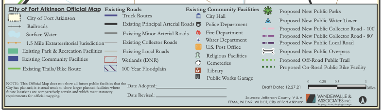
The tool that documents this planning is known as the official map, with which the comprehensive plan and its associated maps must agree. The comprehensive plan must be revised for the official map to be adopted.
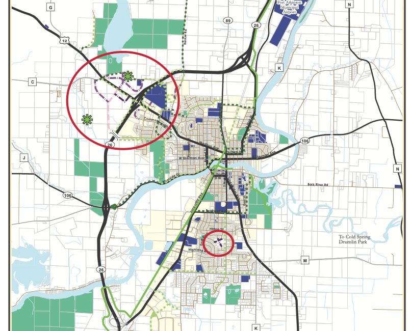
The official map has focused on two areas; the northwest portion of the city and an area on the south side of the city adjacent to the municipal boundary. The latter is acreage owned and being sold by Jim and Patricia Merriman.
“The city plans to complete additional planning in the southeast and southwest areas, as well, and will bring those additions through the same adoption process when ready,” Selle said in the memo. “Many of the planned corridors exist within current right-of-way, such as paths shown adjacent to existing roads. Other right-of-way corridors exist on private parcels.”
Once the ordinance moves through the public process of review and approval, the proposed development within the footprint of these mapped features will require approval by the city.
“If land is not developed and continues as agricultural or natural, a right-of-way shown on the map in such a private parcel has no bearing on the owner’s continued use of the land in this way,” according to Selle. “However, if the owner or a subsequent owner decides to develop the parcel into something other than agricultural or natural, the City of Fort Atkinson becomes an approving authority with respect to the impact the development may have on the mapped features on the parcel.
“Practically speaking, the official map allows the city a seat at the table as the development, which remains in the town (rural township), is planned and approved” he added.
During the meeting, Selle reiterated points in his memo.
“As we’re looking at the growth of Fort Atkinson —which grows slowly, but does grow — we’re looking at where we want particular roads to continue and how to make sure that beyond our borders, in particular, that right-of-way is known to those looking at development in those areas, and that we have a seat at the table when those developments move forward,” Selle said.
He cited as an example a potential Montclair Street overpass of the State Highway 26 bypass on the northwest side of the city. While there is no timeline or budget for this right now, the Crown of Life Christian Academy is building a school and Fort HealthCare owns acreage west of the bypass.
“The only time this (official map) comes into play as a planning tool for the city is when the area becomes developed,” Selle said.
He called the comprehensive plan a “roadmap for the city” that is reviewed annually.
One notable change was the removal of a future U.S. Highway 12 bypass of the city.
“That was a relic from the 2009 map and also left in the 2019 update, and my information from the DOT (state Department of Transportation) is that that is a completely dead project,” Selle told the commission. “And really, we don’t see traffic volumes increasing to the point where that would be resurrected in any near future scenario.”
Also among the changes was replacing some potential recreational trails on the northwest corridor with parkland.
“These are planning changes,” Selle said. “These are no changes that are set in stone by any means and changes that would prohibit or inhibit the existing uses of these lands. They only come into play as these lands develop.”
Commissioner Jill Kessenich asked about removing the potential trails from the plan.
“The trail plan was not as well-thought-out as the park,” Selle explained, noting that the area in question would be preserved anyway due to drainage or wetland issues.
“The thought was that by removing the trail features that aren’t quite as well-thought-out and by putting in the park, we know that we would have some sort of access that comes to the park, and that would require more diligent thought of extending a trail system out to that area,” he said.
The commission unanimously adopted a public participation plan relating to the comprehension plan amendments ensuring several opportunities for citizens to provide input.
A joint council and Plan Commission meeting and public hearing on the comprehensive plan amendments is slated for 6 p.m. Tuesday, Feb. 1.
It will take place in the council chambers, and also be available virtually via Zoom. The meeting link is : https://us02web.zoom.us/j/81717689126?pwd=K0FrK3V0ODlzSmo2blpYSG9ManAyQT09. The meeting ID is: 817 1768 9126, and the passcode is 631861.
The comprehensive plan and the proposed amendments are available for review online at: http://www.fortatkinsonwi.net/index.php Written comments on the proposed amendments should be submitted before the public hearing date to City Clerk Michelle Ebbert at miebbert@fortatkinsonwi.net All written comments will be forwarded to the council and Plan Commission.
Also meeting Tuesday, the Ordinance Committee reviewed the same proposals relating to ordinance changes and moved them to the city council for its consideration when it meets Jan. 18.
In other business Tuesday, the commission approved a request for a front wall sign and panel in a group development sign for the Extreme Smoke, 1642 Madison Ave.
The location is between the ShopKo Optical and the Dunkin’ Donuts sites.
Commissioner Roz Highfield asked whether there had been any consideration regarding a shop selling tobacco and vaping products and electronic smoking devices being close to the high school.
City Manager Rebeca Houseman LeMire said yes, but not in time for Extreme Smoke’s location.
The thinking is “let’s make sure we’re trying to protect our individuals in the schools from this type of use,” she said. “To that end, the city’s Ordinance Committee is meeting tonight and they are reviewing an ordinance change to, in the future, require a use such as this be located at least 1,000 feet from a public or private school.
“While we could not do anything for this particular case, we are looking at an ordinance change to essentially prevent that from happening again,” she added.
It was noted that the legal age to purchase tobacco products is 21 and customers are required to be asked to show an ID.
Ebbert pointed out that Extreme Smoke was issued a tobacco license for retail.
“Those licenses are notified to the state … our police department is well aware and they do compliance checks with these type of businesses in the city, as with grocery stores and gas stations that also have a similar license. So it is not by the wayside that there are age restrictions on these products, and our police department is very active to make sure that the products do not get into the wrong hands.
“Unlike (when selling) alcohol products, no operator’s license (is needed for clerks). They just have to card individuals to be of age,” she added.
A story, relating to a proposed ordinance about smoke shop locations and schools, is here: https://fortatkinsononline.com/proposed-ordinance-limits-proximity-of-smoke-shops-to-high-school/.
In addition to Selle, Highbury, Kessenich and LeMire, Plan Commission members include council representative Mason Becker and Commissioners Eric Schultz and Davin Lescohier.
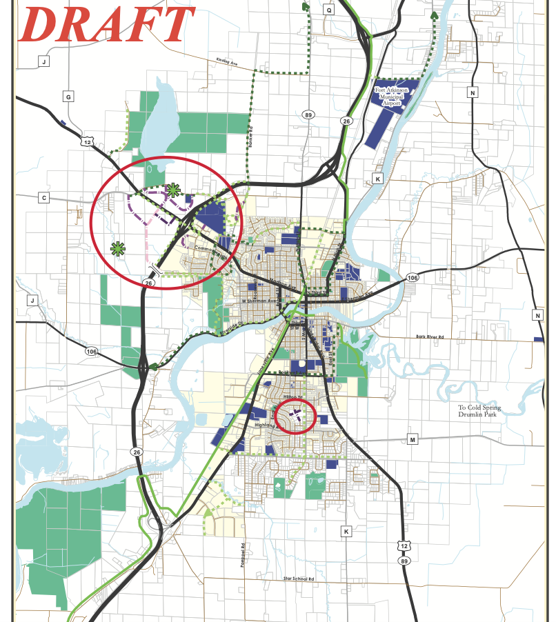
The above graphic represents a draft of the official map as shared with the Plan Commission Tuesday. The circled area on the city’s northwest side shows changes including a potential Montclair Street overpass of the State Highway 26 bypass and also includes future parkland. The circle in the center of the city shows property along South Main Street. The land is for sale and and has been identified for possible future development.
This post has already been read 2318 times!